Navigation and Wayfinding with an iPhone


I’ll admit it: I’m a map nerd. Sometimes I wish I could get by with a photocopied cue sheet taped to my top tube—but I know myself—I like to learn the terrain I travel through. I like to look at a map and analyze the topo lines, figure out the name of the surrounding buttes, notice an old cemetery up the hollow to my left, and then when I inevitably get lost trying to find it, locate an alternate route home.
Paper maps are great. The amount of detail and finesse put into good printed maps these days is a thing of beauty. Someday I’ll buy every quadrangle in Oregon and wallpaper my studio with them. But they have their drawbacks. They get wet, they get bulky on a big trip, you constantly have to refold them, and, well, they don’t tell you where you are.
GPS units are terrible. GPS technology itself is amazing, but the manufacturers of the devices are about 10 years behind other mobile tech when it comes to interface design. To use GPS for wayfinding one needs to plunk down several hundred dollars, learn a clunky new interface, buy proprietary maps for each area you want to explore, and curse up a storm when trying to get your new toy to talk to your computer. If you use a GPS for recording ride tracks and statistics—great—GPS works splendidly for that. GPS units are great for telling you where you’ve been, but abysmal for seeing where you want to go.
Enter the iPhone. I’m no Apple fanboy (I waited 4 years to ditch my dumbphone) but the iPhone is an amazing machine. It’s an emergency call, an encyclopedia, a camera, a calculator, a notepad, a flashlight, a stereo, a store, a TV, an alarm clock, a weather station, and a detailed map of the whole world telling me exactly where I am on its surface. It’s amazing.
PROS:
- No extra space/weight
- Highly detailed yet easy to see overview
- Load routes beforehand
- See exactly where you are
- Switch between topo/map/satellite/USFS and more map tile data sources
- Cache map tiles for areas with no service
- Record trips as GPX files
CONS:
- Not waterproof
- Use of GPS chip drains battery extraordinarily fast
- Small screen
- Local park/forest/BLM printed maps are sometimes more detailed
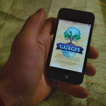
Most people don’t realize that the GPS chip in the iPhone functions perfectly fine whether or not you have cell service. Of course you do still need cell service to load the map tiles in the native Apple Maps app. That’s where the Gaia app comes in. It’s on the pricier end of the App Store at $19.99, but it paid for itself the first time I used it. You can preload tracks, record trips, switch between a bunch of different map sources, see where you are, what direction and how fast you’re traveling, and most importantly download maps for offline use. (I highly recommend RideWithGPS.com to plan out trip routes beforehand.)
All this functionality come with a price: your battery will only last a few hours. The easiest solution is keep your phone in airplane mode and the screen brightness turned down. This shuts off all communication to the satellites and keeps you in that comforting glow for a bit longer. Another system I use is an external battery pack. There are a number of options available—I use a Powergen that holds about 6 full iPhone charges and is a only a little bigger and heavier than the iPhone itself.
The best solution to battery life, unfortunately, is also the most expensive: a dynamo hub. I have two bikes with Shimano Alfine Dynamo hubs and have had zero issues over thousands of miles. The hubs work great. There are more expensive and fancier hub options out there, but if it aint broke don’t fix it: I like my Alfine.
I’ve tried a number of dynamo powered USB chargers and the only system I’ve found to be reliable is the Busch & Müller Luxos U. It also happens to be attached to the best headlight I’ve ever seen or used. The headlight has an external handlebar switch with a USB port. From there I route a USB cord to my phone on the stem. I use a Lifeproof waterproof case and handlebar mount. It’s so efficient I can walk my bike at a fast clip and the phone will keep a charge. While riding I can run Gaia with the screen on full brightness searching for service and still be at 100% battery life at the end of the day. No more fumbling with maps or cue sheets or airplane mode or waiting for something to load. I can ride and navigate without skipping a beat.
In summary: Dynamo wheel + Luxos U light with USB port + Lifeproof case & mount + iPhone + Gaia App.
An added bonus is that now you have the best dynamo headlight on the market as well as a USB charging station. This means I can virtually eliminate batteries from my camping kit. I can charge my water treatment system (Steripen Freedom), my headlamp (Petzl Tikka 2 Core), my DSLR batteries, and a whole slew of other USB devices that are probably completely unnecessary to bring on a camping trip.
I’m sure you’re thinking “that’s a lot of tech just to look at a maps.” And you’re right, it is complicated, but I like it and works for me. Donnie from Velodirt still prefers paper Benchmark maps. If you’re riding an established route, Adventure Cycling and Adventure Maps put out some fantastic waterproof maps. Do you prefer cue sheets or elevation profiles instead of maps? Let us know what your favorite wayfinding and navigation tricks are!
If you want to get real nerdy, here is the best guide I’ve found on using your iPhone as a GPS.